Περιγραφή
Extends the WordPress Plugin Leaflet Map with Leaflet Plugins and other functions.
Functions
-
Create an elevation chart profile of a track. There are also acceleration, slope, speed and tempo chart profiles. You can also place multiple tracks on one map.
-
By default Leaflet Map uses tiles from openstreetmap.org or from the tile servers you configured. You can use more and switch between them.
-
Many markers on a map become confusing. You can cluster and shape them.
-
You can use Awesome markers.
-
You can group the elements on the map by criteria and show/hide them.
-
Create an overview map with geo-locations provided in the pages and posts.
-
Get a tooltip when hovering over an element.
-
You can design a choropleth map.
-
You can display the map in fullscreen mode.
-
Reset the map.
-
Gesture handling
-
Manage your files for Leaflet Map.
-
Help to migrate from WP GPX Maps.
-
and more functions.
Included Leaflet Plugins and fonts
Leaflet Plugins
- leaflet-elevation: A Leaflet plugin that allows to add elevation profiles using d3js.
- Leaflet.GeometryUtil
- Leaflet.i18n: Internationalisation module for Leaflet plugins.
- leaflet-rotate: A Leaflet plugin that allows to add rotation functionality to map tiles
- Leaflet.AlmostOver: This plugin allows to detect mouse click and overing events on lines, with a tolerance distance.
- @tmcw/togeojson: Convert KML, GPX, and TCX to GeoJSON.
- D3: Data-Driven Documents
- Leaflet-providers: An extension that contains configurations for various tile providers.
- Leaflet.Control.Opacity: Makes multiple tile layers transparent.
- Leaflet.markercluster: Provides Beautiful Animated Marker Clustering functionality.
- Leaflet.MarkerCluster.PlacementStrategies: Styling Markerclusters.
- Leaflet.ExtraMarkers: Shameless copy of Awesome-Markers with more shapes and colors.
- Leaflet.FeatureGroup.SubGroup: Grouping of Leaflet elements by options and features.
- Leaflet Control Search: Search Markers/Features location by option or custom property.
- leaflet-choropleth: Choropleth plugin for Leaflet (color scale based on value).
- leaflet.zoomhome: Provides a zoom control with a “Home” button to reset the view.
- leaflet.fullscreen: Simple plugin for Leaflet that adds fullscreen button to your maps.
- Leaflet.GestureHandling: A Leaflet plugin that allows to prevent default map scroll/touch behaviours.
- turf: Advanced geospatial analysis for browsers and Node.js
Font
Documentation
Detailed documentation and examples in German and English.
Thank you
Many thanks to everyone who found errors and provided ideas for new functions.
Στιγμιότυπα

Track with elevation and other profiles and Switching tile layers 
Περάστε το ποντίκι πάνω από περιοχή Geojson 
Markercluster and Groups 
Markercluster PlacementStrategies 
ExtraMarkers 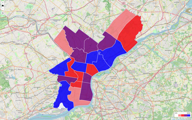
Choropleth Map (data from Choropleth plugin example) 
Files for Leaflet Map
Εγκατάσταση
- Πρέπει να εγκαταστήσετε το πρόσθετο Leaflet Map.
- Then install this plugin.
- Μεταβείτε στις Ρυθμίσεις – Leaflet Map – Extensions for Leaflet Map και λάβετε οδηγίες και επιλογές.
Συχνές Ερωτήσεις
-
Is there a widget or other support for the editor?
-
- Unfortunately both plugins – Leaflet Map and Extensions for Leaflet Map – only work with shortcodes.
- If you have any questions please ask in the forum.
-
My gpx file is not displayed!
-
- Is the URL correct?
-
Does the webserver return the correct mime type (application/gpx+xml)?
Put in your.htaccess:AddType application/gpx+xml gpx
RewriteRule .*\.gpx$ – [L,T=application/gpx+xml]
-
It doesn’t work!
-
- Are you using any caching plugin? Try to exclude at least these js files from caching:
- /wp-content/plugins/extensions-leaflet-map/leaflet-plugins/leaflet-elevation-*
- /wp-content/plugins/extensions-leaflet-map/leaflet-plugins/leaflet-gesture-handling-*
- Are you using any plugin to comply with the GDPR/DSGVO? There might be a problem with that.
- If you use a caching plugin and a GDPR/DSGVO plugin you need to distinguish whether the user has accepted the cookie or not.
- Please ask in the forum!
- Are you using any caching plugin? Try to exclude at least these js files from caching:
-
Apropos GDPR/DSGVO
-
- If you need a plugin for this try DSGVO/GDPR Snippet for Extensions for Leaflet Map.
- If you use Complianz | GDPR/CCPA Cookie Consent see here.
Κριτικές
Συνεισφέροντες & Προγραμματιστές
“Επέκταση για το Leaflet Map” είναι λογισμικό ανοιχτού κώδικα. Οι παρακάτω έχουν συνεισφέρει στη δημιουργία του.
ΣυντελεστέςΤο “Επέκταση για το Leaflet Map” έχει μεταφραστεί σε 2 γλώσσες. Ευχαριστούμε τους μεταφραστές για τις συνεισφορές τους.
Μεταφράστε το “Επέκταση για το Leaflet Map” στην γλώσσα σας.
Ενδιαφέρεστε για την ανάπτυξη;
Περιηγηθείτε στον κώδικα, ανατρέξτε στο αποθετήριο SVN ή εγγραφείτε στο αρχείο καταγραφής αλλαγών ανάπτυξης μέσω RSS .
Σύνοψη αλλαγών
4.2.4.1 / 240423
4.2.4 / 240423
- Bug in overviewmap (negative lat, lng)